Earth & space
River to delta
Earth science · Fluvial geomorphology
 Open the interactive 3D model →
Why do rivers wiggle across flat land instead of running straight to the sea?
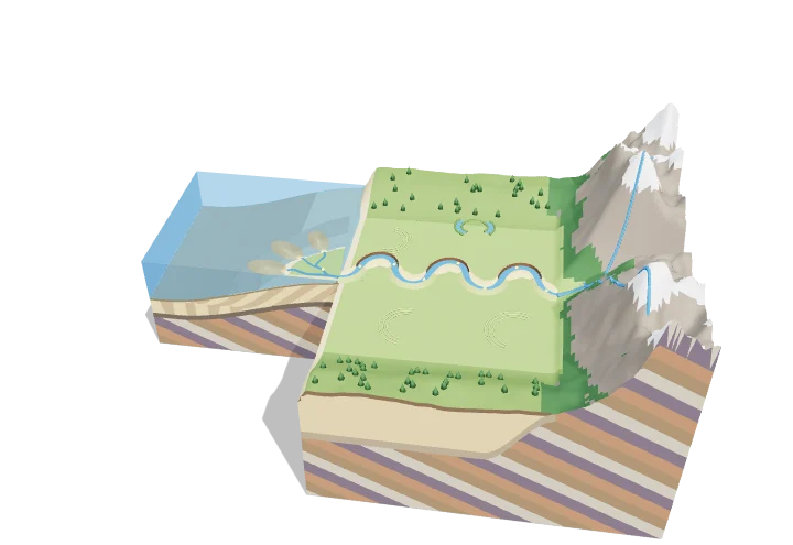
A river picks up sand and mud in the steep mountains and carries it downhill. On flat land it swings into loops, eating away the outside of each bend and dropping sand on the inside, so the loops slowly creep sideways. At the sea the water slows down, drops its load and builds new land called a delta.
A river system carries water and sediment from eroding uplands, across a floodplain where a meandering channel continually reworks its own deposits, to a delta where the load is dumped into standing water. Bends migrate by cut-bank erosion and point-bar deposition, and the delta advances seaward as foreset beds build out beneath a growing delta plain.
Key facts
- Meander wavelength
- ≈ 10–14 channel widths
- Bend radius of curvature
- ≈ 2–3 channel widths
- Meandering threshold
- sinuosity > ≈ 1.5
- Typical bend migration
- ≈ 1–5% of channel width per year
- Global sediment to the sea
- ≈ 15–20 billion tonnes per year (suspended load)
- Foreset slopes
- from < 1° (muddy deltas) to 20–30° (coarse Gilbert deltas)
Parts you can explore (13)
- Mountain headwaters
- Floodplain
- Meandering channel
- Cut banks
- Point bars
- Natural levees
- Oxbow lake
- Delta plain
- Distributaries
- Sediment fan
- Delta deposits
- Bedrock strata
- Sea
In the 3D model
Rotate and take apart the model, follow a guided tour of what each part does and why it’s needed, change it with a live slider, and test yourself with a short quiz. Free, no sign-up.
OpenArc Models’ models are simplified teaching schematics. Terms · Privacy