Earth & space
Fold mountains
Earth science · Orogeny
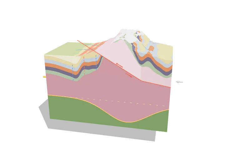 Open the interactive 3D model →
Why is there sea-floor limestone on the top of Mount Everest?
Mountains like the Himalaya form when two continents crash into each other very slowly, about as fast as your fingernails grow. The rock layers between them get squashed sideways, so they bend into giant wrinkles and break and stack up. Layers that formed under an ancient sea end up lifted kilometres into the sky.
When two continents collide, horizontal compression shortens the crust by folding its layers into anticlines and synclines and stacking them along thrust faults, while the thickened crust sinks into a buoyant root that supports high topography. Erosion strips the rising range, exposing deep crystalline rocks and filling a foreland basin, as in the Himalaya.
Key facts
- India–Asia collision began
- ≈ 50 million years ago
- Convergence rate today
- ≈ 40–50 mm/yr (India relative to Eurasia)
- Highest peak
- Mount Everest, 8,849 m
- Crust beneath Tibet and Himalaya
- ≈ 70 km thick (normal ≈ 35 km)
- Airy root-to-height ratio
- ≈ 5–6 : 1
- Erosion / exhumation rates
- ≈ 1–10 mm/yr in the high Himalaya
Parts you can explore (11)
- Folded strata
- Thrust sheet
- Thrust fault
- Anticlines
- Synclines
- Crystalline basement
- Crustal root
- Mantle lithosphere
- Foreland basin
- Erosion
- Plate convergence
In the 3D model
Rotate and take apart the model, follow a guided tour of what each part does and why it’s needed, change it with a live slider, and test yourself with a short quiz. Free, no sign-up.
OpenArc Models’ models are simplified teaching schematics. Terms · Privacy